


Knightwood Chase is surrounded by numerous walking and cycling routes offering sustainable access to Fordingbridge Town.
Take a look at your local cycle routes and footpaths below:
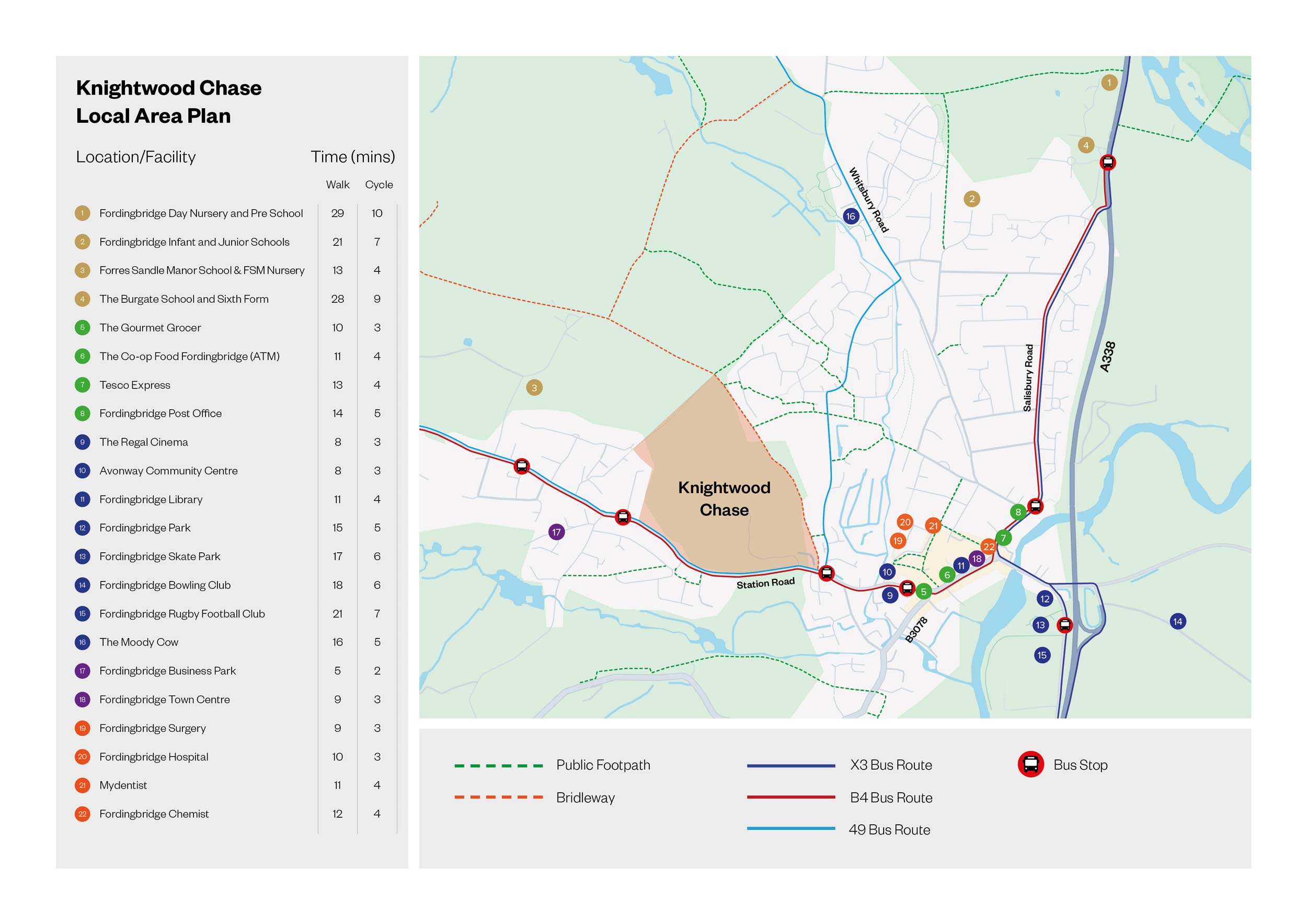
Walking facilities are provided locally to the site, with a footway running along the southern side of Station Road which bounds the Site’s southern boundary. Station Road connects Ashford Village to Fordingbridge town centre, and the footway continues for its entirety, from the roundabout between Station Road and Ashford Road to Shaftesbury Street in the west and east directions respectively.
A number of public rights of way (PRoW) are located within the immediate vicinity of the site, the most relevant being the bridleway route 80 forming Marl Lane. The bridleway runs along the eastern border of the Site, where it continues travelling north up Marl Lane, from Station Road to Rockbourne Road and Whitsbury Road.
For other information and to find alternative walking routes in the area and beyond please visit:
The National Cycle Network provides huge benefits to health and wellbeing, with 4.4 million people using the network between 2017 and 2018. 786 million walking and cycling trips were made on the Network. As a result, £88 million was saved through reduced road congestion.
The Regional Cycle Network Route NB (RCNRB) is a regional cycling route which routes between Alderbury to Shaftesbury in the north and south where it adjoins with the National Cycle Network Routes 24 and 253 respectively. The RCNRB is most easily accessed at the mini roundabout junction between Salisbury Street / the B3078 Bridge Street / the B3078 High Street in the centre of Fordingbridge.
For more information on the National Cycle Network visit the SUSTRANS website. You can also view the National Cycle Network map here as well as getting in touch for more information.
| Cookie | Duration | Description |
|---|---|---|
| cookielawinfo-checkbox-analytics | 11 months | This cookie is set by GDPR Cookie Consent plugin. The cookie is used to store the user consent for the cookies in the category "Analytics". |
| cookielawinfo-checkbox-functional | 11 months | The cookie is set by GDPR cookie consent to record the user consent for the cookies in the category "Functional". |
| cookielawinfo-checkbox-necessary | 11 months | This cookie is set by GDPR Cookie Consent plugin. The cookies is used to store the user consent for the cookies in the category "Necessary". |
| cookielawinfo-checkbox-others | 11 months | This cookie is set by GDPR Cookie Consent plugin. The cookie is used to store the user consent for the cookies in the category "Other. |
| cookielawinfo-checkbox-performance | 11 months | This cookie is set by GDPR Cookie Consent plugin. The cookie is used to store the user consent for the cookies in the category "Performance". |
| viewed_cookie_policy | 11 months | The cookie is set by the GDPR Cookie Consent plugin and is used to store whether or not user has consented to the use of cookies. It does not store any personal data. |